
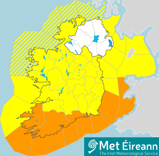
A Status Orange Rain Warning for Waterford will be in place from 10.00 pm, Thursday, 22 October to 5.00 am, Friday, 23 October, with a Status Yellow Warning for Rain and Wind for Ireland in effect from 7.00 pm this evening, Thursday, 22 October until 10.00 am, Friday, 23 October.
Storm Austen is forecast to track eastwards across the county from Thursday evening to Friday morning, bringing intense rain and strong easterly winds, with potentially strong gusts exceeding 100 km/h.
Potential impacts are likely to include localised flooding from urban and fast responding smaller watercourses/catchments, drains, channels and flooding from overland flow, fallen trees and branches and loose debris resulting in very difficult travelling conditions. Higher catchment areas will also be prone to flooding due to the high levels of soil saturation.
With weather expected to remain unsettled over the Bank Holiday weekend, events may also be impacted by the weather warning, and event organisers are advised to assess risks ahead of proceeding with outdoor events. The weather is anticipated will remain unsettled over the bank holiday weekend with the arrival of Storm Boelo, with impacts being felt until at least Monday.
Following a meeting of Waterford City and County Council’s Severe Weather Assessment Team (SWAT) this afternoon (Thursday, 22 October), proactive preparations are being put in place to deal with the potential impacts of this multi-hazard event.
As part of these preparations, ground crews are clearing fallen leaves and debris particularly in low-lying and flood-prone areas, where drainage gullies can become obstructed during periods of heavy autumn rainfall. The crews will be on call throughout the night to deal with issues as they arise, such as blocked drains and gulley overflows, while Waterford Fire Service and the Swift Water Response Teams are prepared to mobilise.
In the event that sandbags are required, they will be available at Waterford City and County Council Depots in Dungarvan (X35 N793) Carrickphierish in the city (X91 N40T), Tramore (X91 PV08), Leperstown, Dunmore East (X91 YH90), and Tallow (P51 VX71) and also at Clashmore GAA Centre (P36 ET26) and Siopa Nua and Passage East.
Waterford City and County Council advises the public to exercise caution, heed public safety advice and avoid unnecessary journeys as driving conditions may be hazardous, with surface water flooding expected.
Motorists are urged to slow down; increase stopping distances and watch for surface water and debris on roads. Avoid driving through flowing or standing water and if the road ahead is flooded, do not enter, turn around and find another route. Motorists are also reminded to be conscious of vulnerable road users such as pedestrians and cyclists.
Motorists are also advised to avoid parking overnight in low-lying areas and carparks that are prone to flooding, such Davitt’s Quay, The Pond, The Lookout and Castle Street Carpark in Dungarvan.
While river levels currently have some capacity and tides are relatively low, members of the public should stay away from coastal areas as conditions can change quickly during severe weather, heeding the advice of the Irish Coast Guard to ‘Stay Back, Stay High and Stay Dry’.
Members of the public can contact Waterford City and County Council’s Customer Services Desk on 0818 10 20 20. Outside of office hours calls will be transferred to the Council’s emergency services number.
Members of the public can contact the Customer Services Desk from 7am on Friday, October 23rd to report any issues.
KEY PUBLIC SAFETY MESSAGES:
Storm Austen is expected to bring high levels of rainfall overnight on Thursday into Friday morning. People should monitor weather updates and heed all warnings issued by Met Éireann. There is the potential for flooding in southern and eastern areas.
Wind speeds will be high in the south, east and midlands. Trees remain in full leaf at this time of year, making them more vulnerable to strong winds.
Secure any loose outdoor items such as bins, garden furniture, trampolines and temporary structures before Thursday evening.
Motorists should be alert for fallen trees, debris and difficult driving conditions, particularly during Thursday night and Friday’s morning commute.
There is the potential for heavy rainfall, particularly in southern and eastern coastal counties. Localised flooding is possible, so never attempt to drive through flooded roads.
While river levels currently have some capacity and tides are relatively low, people should not become complacent. Conditions can change quickly during severe weather.
Allow extra time for essential travel.
People are advised to prepare for this period of severe weather, including ensuring their mobile phone is fully charged to enable communication.
Monitor Met Éireann forecasts and/or visit https://www.met.ie/ for the most up to date information. Information is available across social media platforms and other news media sources.
ESB Networks is highlighting the dangers posed by fallen live wires and is advising the public and the emergency services to stay away from these fallen cables and to report such cases to it immediately. ESB Emergency Services can be contacted at 1800 372 999. The public can monitor www.PowerCheck.ie in regards to power restoration times.
PLEASE NOTE THE FOLLOWING EMERGENCY CONTACT NUMBERS:
- Emergency 999/112.
- Uisce Éireann 1800 278 278.
- ESB Networks 1800 372 999.
- Gas Networks Ireland 1800 205 050.
