
Sections of Waterford’s coastline, stretching between Youghal in the west and Hook Head in the east, are at very high risk of flooding, rising sea levels, storm surges and other coastal hazards which will only exacerbate with climate change, according to a new study from University College Cork.
The new study by UCC researchers examines impacts on coastal Ireland as climate change intensifies and is the first national Coastal Exposure Index, pinpointing where communities, cultural heritage and other coastal assets face the greatest exposure.
The researchers launched a new interactive online map where people can explore the coastal exposure to climate risks, better understand the risks facing the coastal areas and plan accordingly.
The research assessed approximately 8,575 km of Ireland’s coastline at 250-metre intervals, bringing together 30 years of wind and wave data with information on sea-level rise, storm surges, shoreline type, coastal relief and natural habitats.
Global mean sea levels are projected to rise by up to 1.1 metres above 1900 levels by 2100. Approximately 40% of Ireland’s population lives within 5 km of the coast and more than 130,000 people live in areas less than five metres above mean sea level.
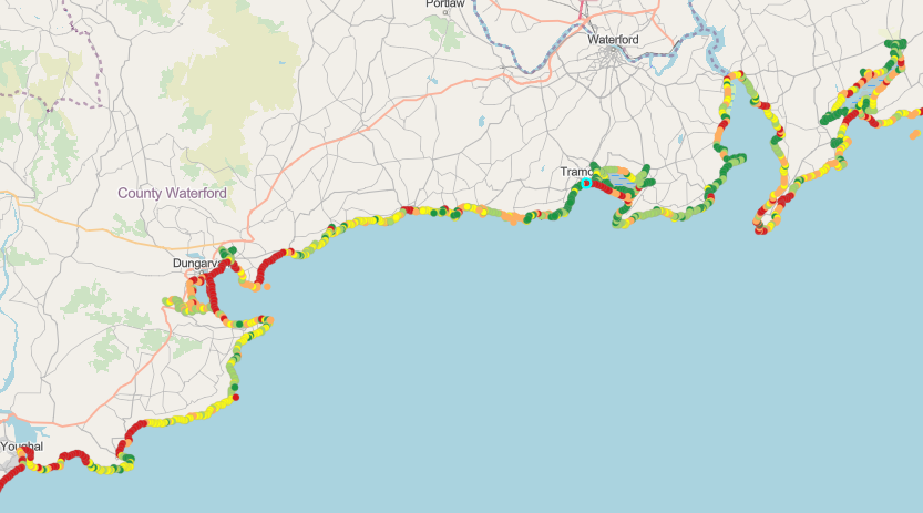
Stretches of the coastline between Youghal and Ardmore show red dots – areas which are deemed as ‘Very High Exposure’. Parts of Dungarvan and Abbeyside, and the entire Cunnigar (land spit in Dungarvan Bay), Clonea Strand, Bonmahon Strand and Tramore Strand also have red dots and are deemed ‘Very High Exposure’. Approximately 14 percent of Waterford’s coastline is deemed to be ‘Very High Exposure’.
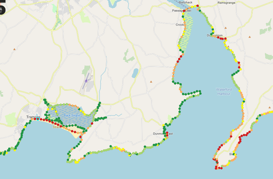
Tramore Strand and Hook Head have a large number of red dots, indicating ‘Very High Exposure’.
These areas are identified as facing the greatest pressures and provides critical new evidence to support coastal management and climate adaptation.
Population and cultural heritage sites within a 500 metre buffer zone of ‘Very High Exposure’ Waterford coastal points were analysed.
It shows that the total number of residents residing within a 500 metre buffer zone of ‘Very High Exposure’ areas is 4,447, which jumps to 4,826 residents in the ‘no habitat scenario’.
The total number of national monuments in the 500 metre buffer zone of ‘Very High Exposure’ Waterford coastal points is 90, but this increases to 92 in the ‘no habitat scenario’.
Kevin Walsh, one of the authors of the study, who is a geoscientist and researcher at the Earth and Ocean Lab, Department of Geography at University College Cork explained that the red dots on the online map show the areas that are deemed to be ‘Very High Exposure’.
“Essentially these areas have exposure scores which correspond to the highest 20% scores from across the country,” said Mr. Walsh, speaking to The Munster Express.
“So, relatively speaking, these are the sites which we found may be mostly likely to be impacted by either erosion, coastal flooding, or damage from extreme winds. In some places, it may be one of those hazards, in others it may be all of them.
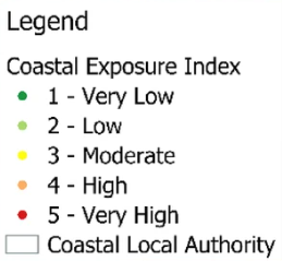
“In the online map, if you click on any coastal point a table should pop up on the left. This gives a breakdown of the variables which comprise the exposure score. These elements are ranked in the same way, with a score of 1 = Very Low, 2 = Low, 3 = Moderate, 4 = High, 5 = Very High.”
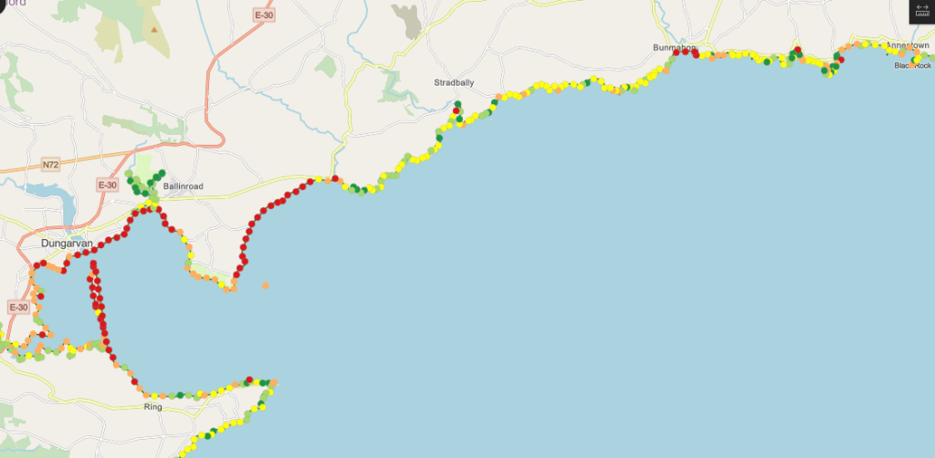
There are red dots around Dungarvan Bay, the Cunnigar and Clonea Strand indicating Very High Exposure’.
NATURAL HABITATS
Historically, solutions to coastal erosion in Ireland have involved hard, engineered structures such as rock revetments, sea walls and groynes, but natural habitats provide a vital protective defence against climate hazards.
According to the study, natural coastal habitats such as sand dunes, saltmarsh, machair and seagrass can have a critical role in reducing exposure to climate hazards for communities and cultural heritage sites, by reducing exposure through lessening the intensity of wave impact, stabilising shorelines and adapting to sea level rise.
The study also highlights how natural coastal habitats can reduce exposure to wave-driven hazards – the Cunnigar in Dungarvan Bay would be considered an important and diverse natural habitat, acting as a natural breakwater shielding the inner harbour, the Quays and western side of the town from heavy coastal waves, storms and rough seas entering Dungarvan Bay.
“So, the Cunnigar, for example, looks like there are values of 5 for Shoreline Type and Relief, meaning the shoreline there is comprised of easily erodible sediment (marine beach sands) and its fairly low lying (averages around <2m above mean sea level).
“It’s exposure to wind and waves tends to be 3 or 4 (Moderate or High). Its exposure to sea level rise is 4 (High), this is because, the south and south west tends to have relatively higher rates of sea level rise when compared with the rest of the country.
“We’ve classified the dune system there as a ‘low, narrow dune’, meaning it offers some protection. There’s also some narrow saltmarsh in the area, which can also stabilise the shoreline and help adapt to sea level rise.
“However, neither the dunes nor the saltmarsh are very extensive, meaning the Habitat score is around 4, so still High (an area with larger habitats will have a lower rank).
“All of those elements combine to give the Cunnigar this ‘Very High Exposure’ ranking. But each individual point around the coast will differ slightly depending on what the coast is made of, which way it faces relative to incoming wind and waves, its elevation above mean sea level and so on,” he said.
Predicting what this means going into the future isn’t something the study looked at.
The exposure scores are based on past records, so how those values change with the changing climate isn’t something they incorporated into the study.
“However, we know that sea levels are rising at accelerating rates and storms appear to be getting more intense, so I think it’s fair to say that those areas deemed ‘Very High Exposure’ now, will likely remain so in the next few decades,” said Mr. Walsh.
“What response is necessary will vary on the region and the particular hazard being faced. One thing we focused on in our study was the potential protection offered by coastal habitats.
“So, for Dungarvan, Cunnigar is offering protection from flooding by essentially slowing the waves and surges down, then investment in preserving those dunes and saltmarshes would be a great option,” he said.
“This is what is referred to as a ‘nature based solution’ for coastal protection, but this only works if the habitats are in good condition. I don’t know the status of Cunnigar but many coastal habitats around Ireland are in a poor condition, so it’s important we invest in protecting these habitats, so they can protect us.
“Of course, many areas don’t have coastal habitats to rely on, so other approaches will be needed,” he added.
He said it is hoped that the study can help Waterford City and County Council and the Office of Public Works in making decisions on what approach they should take to address the challenges faced along the Waterford coastline.
OTHER ELEMENTS DETERMINE RISK
Whether people’s homes will be flooded is still an unanswered question – but it’s important to note that while the study shows exposure, there are other elements determine whether a particular region is at risk.
Giving an example of coastal flooding, Mr. Walsh said there could be two houses next to each other located in a ‘Very High Exposure’ area, but they could have very different risk levels – one house might have a flood barrier while the other house doesn’t, leaving it at a higher risk; and the residents might also be in a vulnerable demographic or socioeconomic group which would also increase their risk relative to their neighbours house – despite both being located near a ‘Very High Exposure’ coastline.
The online map is available to view via a link at www.ucc.ie.
Paul Mooney
